FROST ALERT


ICE WARNING


Top Warning Information Unavailable, error fetching or reading data from the NOAA advisories server.

Regional Radar Regional Infrared Satellite
Radar/Satellite images courtesy of Weather Underground.
METRIC | IMPERIAL
Updated: 20-Apr-2024 @ 6:25am  
Temperature Current Conditions Forecast / Storm Prediction
Currently Outside: Colder 0.4°F than last hour.

21.9°F

Wind Chill:  21.9°F
Feels like: 22°F
---
High Today
32.3°F
12:00 AM
Low Today
21.6°F
6:10 AM
Yest High
55.4°F
5:13 PM
Yest Low
22.2°F
6:10 AM
Sta* High
84.0°F
2016
Sta* Low
21.3°F
2021
* This Station's Records Since 10/2010
Official Record High Official Record Low
Dry Dry

Calm Wind:  SE
0.0

Gusting to:
0.0 mph
Current Snow Snow3:
0.00 in
Chandler Burning Index: LOW Current CBI
Fire Danger:
-2.3 of 100
Overnight

Overnight: Clear
Clear

Lo 29 °F
Saturday

Saturday: Sunny
Sunny

Hi 63 °F
Saturday
Night
Saturday Night: Chance Rain Showers
Chance Rain Showers

Lo 36 °F ↑
Fernwood Idaho Web Cam
Dew Point Liquid Precipitation Wind Speed Sun/Moon
Current: Increased 0.1°F since last hour. 19.2°F
Last Hour: Increased 0.1°F since last hour. 0.1°F
High 12:01 AM: 23.6°F
Low 6:10 AM: 18.6°F
Record High: 72.0°F on
Jun-27-2022
Record Low: -33.9°F on
Jan-13-2024
Wetbulb: 21.1°F
Rain Today
Melt Today: 0.00 in
Yesterday: 0.00 in
Last 7 Days: 0.04 in
Apr Rain: 1.33 in
Apr to Date
  Avg:10
0.00 in
Apr to Date
  Diff from Avg:10
Over 1.33 in for the month 1.33 in
Apr Avg: 2.20 in
Diff from Avg: Under 0.87 in for the month 0.87 in
Season:1 7.95 in
YTD
  Avg:11
0.00 in
YTD
  Diff from Avg:11
Over 7.95 in for the year 7.95 in
Last Rain
Time/Date:
Apr-17-2024
at 2:51 PM
60 rain days in 2024
10 days in April
2 days since last rain
Current: SE  0.0 mph
1Hr Average: Calm
Wind Run: 3.60 miles
Wind Gust
Current: 0.0 mph mph
Today: 8.1 mph 12:54 AM
Month: 29.0 mph Apr-3
Year: 50.0 mph Feb-25
Record Gust: 62.1 mph
Mar-8-2012
Sunlight:
13 hrs 54 min
of Sunlight Today
graph 57.9% 42.1%
Which is
3 min 11 sec Longer
Than Yesterday
 
Waxing Gibbous, 11 days, 19 hours, 6 minutes in cycle
90%
Illuminated
Humidity Barometer
Current: Increased 2% since last hour. 89%
Last Hour: Increased 2% since last hour. 2%
High 6:23 AM: 89%
Low 12:00 AM: 69%
Record High: 98%
Aug-30-2019
Record Low: 0%
Jul-16-2013
Current: Rising 0.005  inHg/hr 30.226 inHg
Last Hour: Steady
High 6:17 AM: 30.229 in.
Low 2:28 AM: 30.206 in.
Record High: 30.956 inHg
Dec-22-2022
Record Low: 29.069 inHg
Dec-29-2010
Heating Degree Days Snow3 Wind Chill Air
Today: 9.2
Apr: 426.9
2024 to Date: 3390.9
Cooling Degree Days
2024 to Date: 0.0
Today: 0.00 in
Yesterday: 0.00 in
Apr Snow: Over 1 in for the month 1.00 in
Apr Avg: 0.00 in
Diff from Avg: 1.00 in
Season Total:2 59.00 in
Snow Depth: 0.00 in
1 snow day in April
21 snow days this season.2
First Snow of Season:
--
Average 1st Snow:
Current: 21.9°F
Low 6:10 AM: 21.6°F
Yesterday: 17.5°F
Record: -36.2°F
Jan-13-2024
Quality
Index6:

18


Good
Density:
1.33 kg/m3
UV Summary/Forecast Solar Summary
Apr-20

Apr-21

Apr-22

Sunrise is at: 5:48 am
Solar Noon: 12:45
Sunset is at: 7:42 pm
Almanac   Station All Time Records Outlook
Current: Morning
YTD Avg Temp: 34.2°F
Sunrise: 5:48 am
Sunset: 7:42 pm
Moonrise: 4:40 pm
Moonset: 4:46 am
Full Moon: -April-2024
New Moon: 03:23 UTC
-May-2024
Support this Site!
Your donation helps support this site
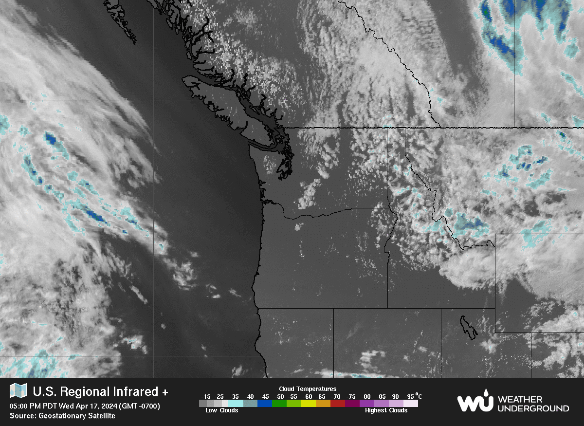
Cloud Height: 628 ft
HIGHS: LOWS:
107.4°F
Aug-10-2018
-28.7°F
Jan-13-2024
Daytime Records
  105.6°F
Aug-10-2018
  -10.8°F
Jan-13-2024
Nitetime Records
  78.6°F
Aug-29-2011
  -18.9°F
Jan-13-2024
Saturday

Saturday: Sunny
Sunny
1 Rain season: Jan 1st to Dec 31st.   2 Snow season Nov 1st to March 30th.   3 Snow manually measured usually around 8AM.   6 Air Quality Index is provided by www.airnow.gov and is updated hourly between the hours of 6AM and Midnight.   10 Historical average only to day 20 of just the month of April for this station since 2010.   11 Historical average rain this season to day 20 of April for this station since 2010.
 NWS Weather Forecast  -   Outlook Overnight & Saturday
Overnight

Overnight: Clear
Clear

Lo 29 °F
NWS forecast: Clear, with a low around 29. East wind around 6 mph.
Saturday

Saturday: Sunny
Sunny

Hi 63 °F
NWS forecast: Sunny, with a high near 63. Southeast wind around 7 mph.